 Underwater 3D Animation for Divers
Go inside the Marie Agnes mine.
The first flooded mine I scanned, back in 2022: an 18th-century silver, lead and zinc working in Lower Silesia with corridors too narrow for fins — documented complete, and now streaming live into your browser.
TL;DR
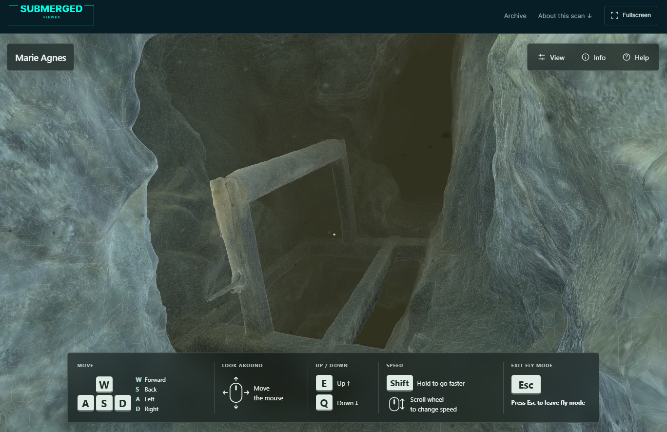
Marie Agnes was my first scan of a flooded mine, shot over four dives in 2022. It is a small site, scanned complete, and until now the only way to be inside it was to watch someone else fly through. It is now live in the browser at viewer.submergedfoundation.org — no app, no login, works on a phone.
Marie Agnes was the first flooded mine I ever scanned. Four dives in 2022, around 12,000 photographs, under 100 m of corridor — a small site, which is exactly why I picked it. Almost everything I know about running a camera in an overhead environment I learned there, mostly by getting it wrong first.
It is also the scan that travelled furthest. It is what got the work noticed outside Poland, and it is why I ended up giving a talk at the NSS Convention in Elkins, West Virginia.
What I could never do was show it properly. Renders are my camera, pointed where I chose. A fly-through is a recording — same path, same speed, every time. To actually be inside the model you had to install something. What was already on the web was a Sketchfab upload from 2022, decimated to 737,000 triangles so a page could load it — about a twenty-fifth of the geometry.
So here it is, the whole scanned mine, live in your browser: Marie Agnes in Submerged Viewer. No app, no login, no account.
Corridors too narrow for fins
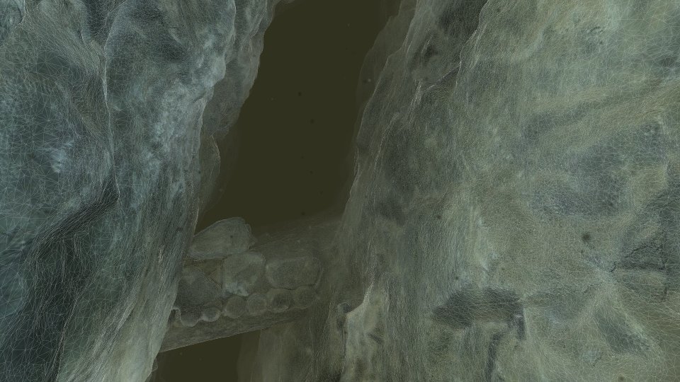
Marie Agnes was dug for silver, lead and zinc in the 18th and 19th centuries, before anyone was blasting. Every metre of it was cut by hand with pickaxes, and you can read that off the walls: the tool marks are still there, and the passages are only as wide as the person swinging the pick needed them to be. In places it is too tight to use fins at all.
It is the site I built a suggested dive plan from — fly the route on a screen, see which restrictions are real, and decide what you are carrying before you get wet.
Why your laptop can handle 18 million polygons
It doesn't — not all at once. The full model streams in as a tree of detail levels: what's right in front of your camera loads at full resolution, everything else quietly resolves to something coarser the further it gets from view. Move closer to a wall and it sharpens under you; look away and it thins back out. It's the same idea game engines use to render a landscape you'll never see all of at once, borrowed here for a mine nobody's engine was ever built for.
Open the View panel, top right, and switch the surface to wireframe or Textured + Wire, and you can watch it happen — the mesh visibly gets denser as you approach a wall, and thins out down the passage behind you.
What you're actually looking at
The published model is 18.4 million polygons and 10.1 million vertices, about 410 MB of compressed geometry and texture that your browser pulls in small pieces, only the pieces it needs, only when it needs them. It runs on a phone, too — touch controls replace WASD, and the detail budget drops a notch so it stays smooth.
The geometry and the colour are as they came out of the reconstruction — photogrammetry textures already carry the light that was in the mine on the day, so nothing gets relit. The viewer puts its own pass over that: fog with distance, particles for the matter hanging in the water, and colour grading across the frame, so the place reads the way it reads from behind a mask.
Try it
Go to the Marie Agnes scan. Click "Start exploring," fly with WASD and the mouse, and go find the shaft.
Marie Agnes is one site in the archive. More scans go up as they're processed.
Marcin Stempniewicz
Cave Diving 3D Photogrammetry Instructor · Underwater 3D Academy
Marcin Stempniewicz is a TDI Full Cave diver, technical wreck diver, and 3D artist based in Poznań, Poland. He founded the Submerged Foundation to document underwater environments that almost nobody will ever see in person -flooded mines, caves, and wrecks -and to bring them back to the surface as accurate, explorable 3D models.
His flagship project is the Maria Concordia flooded magnesite mine, supported by the XDEEP Exploration Support Program. Over hundreds of hours underwater, Marcin and his team worked through four labyrinthine levels and a 40-metre vertical shaft in cold, silt-prone, zero-margin conditions, capturing hundreds of thousands of photographs and reconstructing the entire mile-long site as a single coherent model. The same approach has taken him into the Marie Agnes silver-lead-zinc mine—some 12,000 photos over four dives—the Cold War-era Kowary uranium mine, and the flooded galleries of the Srebrna Góra fortress. He also collaborates with Poland's National Maritime Museum on the digital documentation of wrecks, where a cinematic 3D record is often the only form in which a vanishing site can be preserved.
That field experience is where U3DA comes from. Every scan Marcin has ever brought home hit the same wall: the photogrammetry software produces a mesh, and the mesh is not the story. Wrong scale, muddy textures, a viewer that only another specialist can read. The workflows, lighting rigs, shader setups, and Python scripts he built to solve that for his own expeditions became the course. Outside the water, Marcin co-founded Ar-range, a rendering platform that produces every product variant a furniture brand sells—millions of images from one 3D source—and the same batch-rendering and automation discipline runs through the U3DA workflows.
His work has appeared in InDepth (GUE), XDEEP ESP, divers24, and Podcast Spod Wody. He has presented at Hidden Earth (UK), the NSS Convention (West Virginia 2024, Tennessee 2025), Baltictech, and Dive Expo Belgium 2025, on how accurate 3D documentation changes both cartography and dive planning in overhead environments.
"The raw scan is not the product," Marcin says. "The story non-divers can experience is." At U3DA, he teaches divers, wreck surveyors, marine archaeologists, and underwater photographers—starting from zero Blender experience—how to turn their own scans into cinematic animations that a museum, a sponsor, or a family member can actually watch.
Surfaced with a scan the world should see?
U3DA turns your photogrammetry into full-HD renders, cave fly-throughs and finished dive videos in Blender. No 3D background needed. Start with the free first lesson.
Frequently asked questions
What am I looking at?
Marie Agnes, a flooded silver, lead and zinc mine in Lower Silesia, Poland, worked in the 18th and 19th centuries and reconstructed from around 12,000 photographs taken over four dives.
Is this the whole mine?
It is the whole of what was scanned — under 100 m of flooded corridor, documented end to end. The mine itself has three levels, the lower two of them underwater; this is the part I dived.
How can an 18-million-polygon scan run in a browser without installing anything?
It does not load all at once. The viewer streams in only the level of detail your current view actually needs, the same multi-resolution trick game engines use for large open worlds.
Does it work on my phone?
Yes — touch controls replace the keyboard and mouse fly controls, and the detail budget is lower so it stays smooth on weaker hardware.
Can I use this for something other than looking at it?
Yes — Marie Agnes is the site I built a suggested dive plan from. A model like this lets a diver fly the route, judge the restrictions and decide what to carry before anyone gets in the water.